Style Explorer
The Style Explorer component is used to access and manipulate the style associated with the layer. For every layer with geometric (point, line and polygon) or raster representation, there is always an associated default style.
It is accessible through:
LAYER EXPLORER or → right click over a layer-name → STYLE EXPLORER
SHOW → STYLE EXPLORER
The explorer style has three distinct components:
Style Explorer: Uses a tree structure (style, rule and symbolizer) to represent the hierarchy of the style associated with the layer. The tree structure is shown bellow with examples of styles for polygon, line and point:
Style: It is the top level and represents the layer style. A style can have more than one rule, each one can represent a restriction over the data. The default behavior is one rule per layer without restrictions.
Rule: A rule is composed by a set of symbolizers defined in the next tree level. The default rule has no restriction and includes all data.
Symbolizer: Once a rule is selected, use the tool bar do add, remove and move up/down the symbols that will compose the rule. The Symbology component explains how to define symbols.
Tool Bar: It provides tools to manipulate the symbols:
![]() is only a shortcut
to the Draw Tool in the application and draw the layer using the
defined style.
is only a shortcut
to the Draw Tool in the application and draw the layer using the
defined style.
![]() add a new symbol to
the rule. Initially, the symbol added is a clone of the selected
symbol (default). To change the properties that define its symbology
go to Symbology component.
add a new symbol to
the rule. Initially, the symbol added is a clone of the selected
symbol (default). To change the properties that define its symbology
go to Symbology component.
![]() removes the
selected symbol from the rule.
removes the
selected symbol from the rule.
![]() and
and
![]() changes the order of the symbol in the rule.
changes the order of the symbol in the rule.
![]() it is used to change
the scale of the symbols used to compose the rule and displays at
preview. It will not take effect on the Map Display.
it is used to change
the scale of the symbols used to compose the rule and displays at
preview. It will not take effect on the Map Display.
![]() it is used to open a
library manager from where is it possible to seach and pick up the
symbol.
it is used to open a
library manager from where is it possible to seach and pick up the
symbol.
Symbology: This component allows the user to modify the symbol, accessing all properties belonging to the selected symbols. The details may vary depending on the feature being represented. The feature types and their properties are listed bellow and the links leads to the Symbolizers session:
Polygons:
Basic Symbology
Graphic Symbology
Lines:
Basic Symbology (only stroke)
Points:
Graphic Symbology
Raster:
Raster Symbology
Symbolizers
A Symbolizer is an abstract type for encoding the graphical properties used to portray geographic information. A Symbolizer describes how a feature will appear on a map. The Symbolizer describes not just the shape that should appear but also such graphical properties as color and opacity. A Symbolizer is obtained by specifying one of a small number of different types of Symbolizers and then supplying parameters to override its default behaviour.
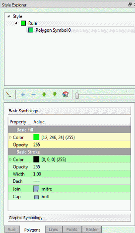
Basic Symbology
Basic Fill
A Fill specifies the pattern for filling an area geometry.
Properties:
Color: Sets the color used to draw the fill.
Opacity: Sets the opacity to draw the fill.
Basic Stroke
A Stroke specifies the appearance of a linear geometry.
Properties:
Color: Sets the color for the contour drawing.
Opacity: Sets the opacity for the contour drawing.
Width: Sets the width for the contour drawing.
Dash: Sets the dash for contour drawing.
Join: This property defines how a line should be joined (between line segments).
Cap: This property defines how a line should be capped (at the two ends of the line).